Winter in Munsiyari: Face to Face with the Panchachuli Peaks

Seven years after my first visit, I returned to Munsiyari in winter hoping to see a landscape that had remained hidden before. The mountains had their own plans.
I stepped out of my hotel in Munsiyari before dawn and waited for a shared taxi to begin the journey to the plains. As I looked towards the sky, a dark ridge cut across the horizon. Above it, thick clouds drifted over the Panchachuli range, hiding most of the snowline from view.
My phone rang a few minutes later. “I’m picking up a few passengers near the main market. It’ll take another twenty minutes to reach your pick-up point.” The delay changed the final moments of the trip.
The clouds split as the sky shifted towards daylight. A sharp diagonal streak of amber light cut across the dark blue sky, revealing the five snow-covered peaks of Panchachuli emerging through the mist.
The opening closed within minutes. Clouds swept across the range before the taxi reached the hotel. By the time I left Munsiyari, the peaks had disappeared again.
The journey ended with an unfinished desire. I had seen Panchachuli, but never face-to-face.

The years that followed reshaped the way I travelled. The pandemic interrupted movement before a growing interest in landscape photography altered how I approached the road. Mountain journeys continued, while forests, wetlands, coastlines and wildlife habitats added new directions to the map.
I revisited Chitkul in Kinnaur, a village I had first seen during the monsoon years earlier. Snow covered the settlement and transformed the surrounding slopes. The journey reinforced a simple lesson: a familiar landscape can reveal an entirely different character under different seasonal conditions.
Winter snowfall across Kumaon grew weaker and less predictable. Each winter ended with the same outcome. The conditions needed for a return never aligned. Munsiyari remained unfinished.
Early in 2026, that pattern began to shift. Forecasts pointed towards fresh snowfall across Kumaon after years of mild winters. There was no certainty that the mountains would receive enough snow, but the possibility was stronger than before.
The signal was enough to commit to another journey towards Munsiyari.
Hyderabad to Kumaon: The Rail Route That Skips Delhi
Munsiyari lies deep within the eastern reaches of Uttarakhand’s Kumaon region. My earlier journeys into Kumaon followed the familiar route through Delhi before continuing from Haldwani into the mountains.
Frequent trains and Uttarakhand Transport Corporation (UTC) buses make this the most common approach, but Delhi’s heavy transit volume keeps the network crowded through much of the year.
For my 2026 return to Kumaon, the first decision came long before planning the mountains. I wanted to bypass Delhi altogether. The answer lay on the railway map.
Instead of entering the capital, the Hyderabad–Delhi rail corridor could connect with another line branching towards Kumaon’s foothills from Agra. That single interchange became the key to avoiding Delhi while still reaching the gateway to the mountains.
With the route decided, I turned to timing. Travelling during the last week of January avoided the usual tourist rush. It also coincided with weather forecasts that hinted at a higher chance of snowfall across the upper Kumaon region.

The journey began aboard the 12647 Coimbatore (CBE) – Hazrat Nizamuddin (NZM) Kongu Express, departing Hyderabad on Monday and arriving at Agra Cantt the following morning. I checked into the railway retiring dormitory to rest before continuing north.
Agra had been part of my childhood years in Delhi and later appeared countless times during rail journeys across northern India. This time I skipped the Taj Mahal. The pause at the station broke the long rail journey before the route climbed into the Himalayas.
Later that evening, a short transfer took me from Agra Cantt to Agra Fort station, where the 15055 Agra Fort (AF) – Ramnagar (RMR) Express departed for Lal Kuan.

Stepping outside Lal Kuan station before sunrise was neither the safest nor the most economical option for a solo traveller. The 16 KM journey to Haldwani often depended on expensive taxis and auto-rickshaws at that hour. Fortunately, another connection solved the problem.
The 14120 Dehradun (DDN) – Kathgodam (KGM) Express departed Lal Kuan at 06:15, allowing a safe onward journey in the train’s unreserved coach.
Thirty-five minutes later, I got down at Haldwani, the final stop on the plains where rails gave way to mountain roads. The UTC bus stand, located a short walk from the station, was the transit point for the climb into Kumaon.
Winter Inside Binsar Wildlife Sanctuary
The road to Munsiyari led towards the higher Himalayas. Instead, I turned towards Binsar Wildlife Sanctuary.
Most travellers pass Binsar on their way to the higher reaches of Kumaon. Strict restrictions on commercial activity have kept much of the sanctuary untouched, sparing it the crowds seen around nearby hill stations.
An online search led me to a family-run homestay on the edge of Binsar Wildlife Sanctuary. Guests spoke about the quiet forest, homemade Kumaoni food and long hours spent watching the Himalayan ranges. It sounded like the right place to pause before continuing deeper into Kumaon.
My Binsar journey resumed aboard a Bageshwar-bound UTC bus from Haldwani. The road climbed through Almora, the largest hill town on the route to the higher Kumaon region.

Our breakfast halt came after we crossed Kainchi Dham, a stretch now known for long-weekend traffic jams. Travelling on a weekday morning avoided the congestion.
As the road climbed into the mountains, food became more functional than elaborate. The dhaba served a fresh thali of dal, kadhi, seasonal vegetables and rotis. The meal was light and warming, built for the long hours of winding hill roads ahead.

I reached Almora around noon. A short taxi ride brought me to the entrance of Binsar Wildlife Sanctuary, where Indian visitors pay an entry fee of INR 250 per person and a round-trip vehicle entry charge of INR 150.
The taxi dropped me off along the forest road towards Zero Point, where one of the family’s sons met me to help with my trolley bag.
As we walked towards the homestay, he told me that the trail would always remain just like this. Under strict Forest Department protection, there is no scope for a motorable road, meaning every guest must cover the final stretch on foot.

After meeting the family, I followed the trail to the guest cottages, which stood about two hundred metres from the family’s own home. My cottage stood on the edge of a ridge overlooking dense pine forest.
Sunlight filtered through the trees while a cool forest breeze drifted across the slope. After the long rail and road journey, the silence felt almost unfamiliar.

The warmth of the stay extended beyond the surroundings. I requested the family not to prepare anything special for me and instead serve whatever they cooked for themselves. Every meal came from their kitchen using ingredients sourced around the homestay.
During the next five days, I experienced the everyday flavours of a Kumaoni home. Bhaang ki chutney, Kumaoni raita and Bhatt ki dal became my favourites.

On the third evening, the weather changed. As daylight faded, snow began drifting across the forest. Thick clouds swallowed the last of the daylight while the first flakes settled on the grass outside the veranda. Under the veranda lights, the snowfall glowed against the dark forest beyond.

Later that night, the power went out as the snowfall intensified. As the temperature fell, every part of the bed left uncovered by the quilt felt as though icy water had been poured over it.
By morning, the valley outside my room had turned white. News reports later confirmed that fresh snowfall had blocked several high mountain roads leading towards Munsiyari.

When I stepped out for lunch, bright sunshine had already begun melting the fresh snow. By afternoon, the forest had almost returned to its usual colours.
Only the distant snow-covered slopes near Ali Bedni Bugyal hinted at what had happened overnight. The forecast for the next few days showed clear skies.
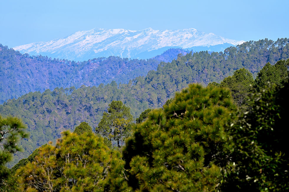
The pause inside Binsar had done exactly what I had hoped. The mountains ahead had received fresh snowfall, and the road to Munsiyari was finally calling again.
Chaukori: Waiting for the Mountains to Return
I left Binsar under clear skies with fresh snow now covering the higher mountains ahead. The road continued towards Munsiyari, but one more stop remained.
Although the distance from Binsar to Munsiyari is only around 200 KM, mountain roads stretch both distance and time. The route drops from Binsar’s oak forests into a deep river valley before climbing through successive ridges towards the higher Himalayas, making it a full day’s journey.
My first trip to Munsiyari in 2019 began from Nainital. Delays and bad weather forced an overnight halt at Thal, a junction town on the banks of the Ramganga River.
The retreating monsoon and the swollen river created a peaceful landscape, but the commercial town lacked the atmosphere I had hoped to find along the way.

This time, I chose Chaukori as a stopover before continuing to Munsiyari. The small settlement sits on a ridge roughly halfway along the route, making it an ideal place to break the journey. On clear days, it also offers one of Kumaon’s finest Himalayan panoramas.
By early afternoon, I reached the Kumaon Mandal Vikas Nigam (KMVN) Tourist Rest House. My ground-floor room looked directly towards the Panchachuli range, turning the large picture window into a frame for the mountains beyond.

After lunch, I stepped outside to explore the property. The broad viewing lawn opened towards an uninterrupted sweep of the Kumaon Himalayas, with Panchachuli rising prominently along the horizon.
It was exactly the panorama I had hoped to see before continuing to Munsiyari.

The mountains began disappearing before evening. Clouds gathered over the ridge, the light faded, and rain settled across Chaukori for the rest of the night.
By morning, the weather had worsened. Thick clouds blanketed the surrounding hills while a steady, cold drizzle continued. Reports confirmed heavy snowfall around Kalamuni Top, the high mountain pass before Munsiyari.
Vehicles attempting to reach Munsiyari had turned back, others remained stranded near the pass, and taxis could no longer complete the journey.

I informed my homestay in Munsiyari that I would arrive a day later and remained in Chaukori. The rain eased late in the afternoon before giving way to a clear night.
The next morning, I watched the first light spread across the horizon but resisted reaching for the camera. The mountains remained in shadow, their snowfields still waiting for the sun.
I finished packing and got ready to leave. By the time I stepped outside, daylight had reached the peaks, revealing the entire Himalayan wall in crisp detail.
The moment reinforced something I had learnt over years of travelling with a camera: not every mountain photograph belongs to sunrise. Sometimes the better light arrives after the golden hour has passed.

Chaukori had revealed the mountains on its own terms. I packed the camera and continued towards Munsiyari.
From Chaukori to Munsiyari
I left Chaukori under clear skies with the Panchachuli range still glowing in the morning sun. The road to Munsiyari would cross Kalamuni Top, the highest point on the route, before descending into the Gori Ganga valley.
We stopped at Thal to refuel. Seven years earlier, I had wandered through the same town searching for any vehicle willing to take me to Munsiyari after bad weather disrupted my plans. This time the road remained open. We crossed the flatter river basin through Nachini and Tejam before the climb began.
Beyond Tejam, the valley narrowed, and the road gained altitude through one hairpin bend after another. Soon a thin ribbon of water appeared high against the mountainside. Birthi Falls lay just around the next bend.
The approach to the waterfall had changed noticeably since my previous visit. What was once an open roadside stop is now managed by the local gram panchayat.
A modest entry fee of INR 20 funds a landscaped trail and visitor facilities making the short climb far more comfortable while preserving the natural surroundings.

The trail climbed through shaded rest shelters before opening onto a wide viewing area opposite the waterfall. A glass viewing platform now extends from the mountainside, allowing visitors to appreciate the full height of the cascade from a safe distance.
The torrent had narrowed to a sharp white fracture line in the stone, exposing the dark rock crevices and jagged ledges that the monsoon canopy usually hides.
Positioned almost halfway to Munsiyari, Birthi Falls also makes a natural pause before the long climb to Kalamuni Top.

The trail descended towards the exit, opening wide views across the valley below. The road we had climbed now traced a thin line across the valley floor. The mountains looked larger from here than they had from the road.
We had already gained more altitude than it seemed during the drive. The pause at Birthi Falls offered a moment to slow down before continuing towards Kalamuni Top, where the road would climb even higher.

Back on the road, the ascent towards Kalamuni Top gathered pace. Hairpin bends climbed steadily through the forest as the first traces of snow appeared beside the road. With every turn, the white banks grew deeper until the roadside disappeared beneath towering walls of snow.
By the time we reached the pass, fresh snow covered the trees and the surrounding slopes. The afternoon sun cast long blue shadows across the untouched surface, bringing out the contours of the snow-covered landscape.
The road had reopened, but the snowfall still defined everything beyond its edges.

Snow continued to line the road long after we left Kalamuni Top. Around one bend, a small cluster of stone houses emerged from the white landscape, their roofs almost level with the surrounding snow.
Beyond them, the high Himalayan peaks stretched across the horizon, now appearing much closer than they had from Chaukori.
The houses marked more than another roadside settlement. They signalled that the long ascent was over and Munsiyari was now close. The mountains were no longer something I had been travelling towards. They had become part of the landscape around us.

The road remained wet where the afternoon sun had begun melting the snow. Water spread across the tarmac before refreezing into thin patches of black ice in the colder shade.
The taxi slid on one icy stretch before regaining grip. It was a quiet reminder that in the mountains, reaching the destination often depends more on patience than speed.

I reached my Munsiyari homestay in the afternoon. After unpacking and a hot shower, I rested for a while. By the time I stepped outside, the afternoon light had softened.
A short walk towards the market brought me to the edge of the road, where a narrow trail dropped towards the school ground below. I stopped there without intending to.

It was a quiet end to a journey shaped by changing weather, long mountain roads and unexpected delays.
The days ahead would no longer be about reaching the mountains, but about living alongside them.
Nanda Devi Temple, Munsiyari and the Panchachuli Range
The next morning I woke up to clear views of the Panchachuli range. The cold air caught my face and bare hands as I opened the balcony door. After the long drive into Munsiyari, the peaks stood clear across the valley.
I had planned to spend the day walking to Nanda Devi Temple, one of the town’s most celebrated viewpoints. Before getting ready, I reached for the camera and isolated one of the peaks glowing in the morning light.

Once outside, a short walk brought me to the edge of the road where the slope dropped towards the large ground below. Most of the snow had melted from the sunlit sections, while a broad white patch still lingered in the shade.
The mountains looked different in the morning. What had been a dark silhouette at dusk now stretched across the horizon in full detail, with the town spread quietly beneath it.

I continued towards the taxi stand, where the walk left the highway and entered a narrower market road.
Hardware shops, small businesses and tightly packed homes lined both sides. The lane carried the rhythm of a working town rather than a sightseeing stop.
The road felt more confined than I remembered. New buildings filled many of the gaps between older structures, and larger vehicles moved through the bends with little room to spare.
Among the morning shoppers and shopkeepers, I was the only tourist.

Beyond the market, the buildings began to thin out, and the valley opened again. At one bend, the petrol pump looked much as it had seven years earlier. The temple still lay farther along the ridge.
A small restaurant nearing completion became my breakfast stop. I sat by the window with a plate of hot aloo parathas and two cups of tea as the morning light spread across the mountains and the town slowly came to life.

After breakfast, I resumed walking along the curved road. Soon the valley opened wide. I stepped onto the grassy edge of the slope for a better view of the mountains.
A local was guiding a small flock of sheep down the hillside. A helicopter crossed the valley, and its noise sent the last of the animals hurrying downhill. The shepherd then climbed a little closer to the road.

"This helicopter keeps flying all day, taking tourists for a quick half-hour ride." He paused and looked across the valley. "The helipad was here long before these tourist flights. There were winters when people died because help could not reach them in time."
When he learned that I was walking to Nanda Devi Temple, he pointed towards the road behind us and then across the valley below.
"This road has remained like this for ages. If it had it been widened, the ridge would have filled with hotels and new buildings. Down there, you can hardly see any houses."
After walking through the crowded market a short while earlier, I understood what he meant.
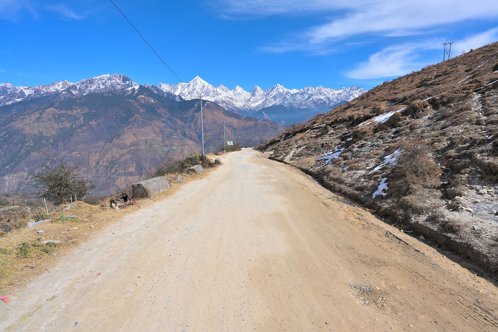
His gaze stayed with me as I resumed the walk. The road ahead remained unpaved, winding along the ridge with the Panchachuli range filling the horizon. There were no long rows of hotels here, only the occasional house set far below on the valley slopes.
In many hill towns, roads like this are often widened first and crowded later. This stretch felt different. The rough surface slowed the journey, but it also left the mountains with room to breathe.
A bend in the road opened the view across several layers of mountains. Pine-covered slopes rose from the valley, giving way to barren ridges and the snowfields above.
One peak held my attention longer than the others. Snow gathered around its sharp summit, and dark rock showed through in narrow bands and gullies.
Far below, a handful of houses clung to the hillside, so small that they seemed to belong to a different world.
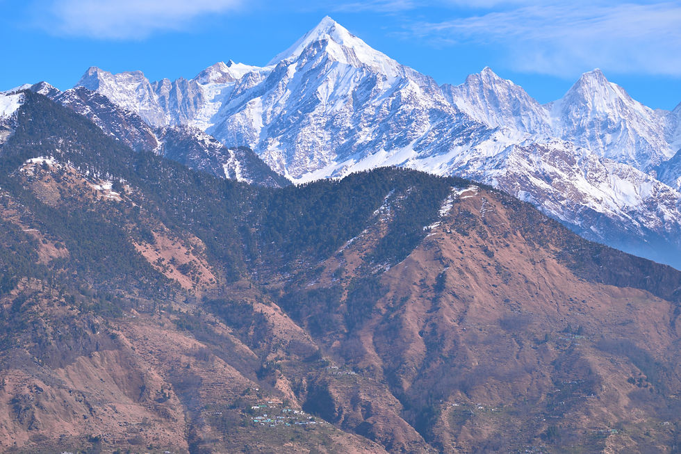
A little farther on, the valley opened again and I recognised a red-roofed house standing alone on a ridge below. I had photographed the same place during my monsoon visit, when the hills were deep green and the clouds hid the higher mountains.
In winter, the colours had drained from the slopes, leaving the house surrounded by brown ridges and long shadows.What struck me most was the contrast above it. The upper peaks carried heavy snow while many of the lower mountains showed only thin white traces.
I am not a scientist, and a single season proves nothing, but standing there it was hard not to think about how often travellers now speak of changing winters in the Himalayas.

As I continued along the road, it entered a shaded stretch beneath the trees. Snow still lined the edges where the sun had not reached, and the air felt noticeably colder than it had on the exposed ridge.
Each turn seemed to pull the mountains nearer. What had begun as a distant wall above the valley now filled more of the sky, with the Panchachuli peaks rising beyond the dark forest and the lingering snow beside the road.

The next bend brought me to the turn for Nanda Devi Temple. A blue signboard stood beside the road beneath bare winter branches. From here, the road gave way to a narrow trail leading towards the meadow where the temple stands.
I left the road and followed the path beneath the trees. White peaks flickered between the branches as the trail climbed away from the traffic.

The path soon reached the temple entrance. The main gate remained closed. A narrow side passage with a rotating barrier let visitors in one at a time. The arrangement was simple, but it kept the flow of visitors controlled without feeling intrusive.
Beyond the entrance, the trees still held back most of the view. The snow peaks appeared only in brief glimpses before disappearing again as the trail continued towards the temple.

A few steps beyond the gate, the trees began to thin. The path opened onto a broad meadow where the temple stood in the distance, and a viewing gallery appeared near the edge. The mountains curved away in a long arc beyond the grounds, while the higher snow peaks remained partly hidden.
The approach felt carefully arranged. A wide grey walkway ran through the open ground, with thick white borders that stood out against the winter grass. Nothing here seemed oversized; the path guided the eye forward and let the landscape unfold at its own pace.

Walking through the grounds, I remembered my previous visit in 2019. The same meadow had looked completely different then. Thick cloud covered the ridge, the distant mountains had disappeared, and the temple stood alone against a shifting grey sky.
That memory made the clear winter morning feel even more striking. I had returned hoping to see what the clouds had hidden years earlier, and now the landscape was beginning to reveal itself step by step.

The contrast with my earlier visit became clearer as I approached the temple. The walkway now continued between bright orange railings, and solar-powered lights stood along the route without dominating the landscape.
The upgrades felt practical rather than ornamental, making the grounds easier to navigate while leaving the mountains as the main attraction.
What impressed me most was the consistency of the design. The railings, pathways, lighting, and viewing structures all followed a similar palette of orange, white, and grey, creating a quiet visual rhythm across the meadow.
The temple remained at the centre of the experience, while the Panchachuli range rose beyond it like a backdrop that needed no introduction.

Standing in front of the temple, I realised that the view here was not limited to a single direction. To one side, the slopes of Khaliya Top rose above the meadow with patches of lingering snow among the forests.
Behind me, the ridge fell away towards the valley, while the Panchachuli range stood beyond the temple.
Few places in Munsiyari offer such a complete sense of the landscape. A small turn of the head was enough to move from temple roofs to forests, from distant valleys to snow-covered peaks.
The meadow felt less like a viewpoint and more like a place where the entire mountain world gathered around a single ridge.

I walked past the temple and towards the outer edge of the meadow. The ground dropped away gently, and the Panchachuli range finally stood across the valley in its full sweep. After the partial glimpses through the trees and the first hints beyond the gate, the mountains no longer needed to be imagined.
Near the bottom of the slope, a small viewing gallery sat against the immense backdrop, almost disappearing into the scale of the landscape. That contrast stayed with me.
The meadow had been redesigned with paths, railings, lights, and shelters, yet everything seemed measured against the mountains rather than competing with them.

The closer I got, the more thoughtful the viewing gallery appeared. The basic octagonal shape remained familiar, but the structure had been rebuilt with a cleaner design.
The roof was now painted deep red, while the pillars and walls followed the same white and grey palette used across the meadow. The shelter no longer felt separate from its surroundings.
Seen from a distance, the gallery had looked insignificant beneath the mountains. Standing beside it, I realised that this was exactly what the designers had intended.
It offered a place to sit, pause, and look out across the valley without drawing attention away from the Panchachuli range behind it.

Inside, the changes were even easier to notice. The old concrete benches had been replaced with tiled seating that ran around the perimeter. Rough dark tiles covered the floor, giving better grip when snow or rain made the ground wet. Above, the roof carried a warm wood finish that softened the otherwise simple structure.
I sat down and looked through the opening. The gallery framed the Panchachuli range almost like a series of windows, breaking the mountains into separate panels while keeping the sweep of the ridge intact.
It was a small architectural gesture, but it turned a place to rest into one of the most memorable viewpoints in Munsiyari.

Another structure in the meadow caught my attention. Built in red brick with a sloping roof and simple white detailing, it looked more like a mountain cottage than a public facility.
The same design language continued here too. Solar lights lined the paths, the colours remained restrained, and the buildings sat low against the landscape instead of trying to dominate it.
With the Panchachuli range behind it, the cottage became a reminder of how much the meadow had changed since my earlier visit. The facilities were better, the paths were more organised, and visitor movement was easier to manage, yet the ridge still felt open to the sky and the mountains.

I spent the rest of the day wandering across the meadow, moving between the open viewpoints and the galleries whenever the light changed. Wherever I stood, the Panchachuli range remained in sight.
By the time I began walking back towards Munsiyari, the sun was already dropping behind the ridges. The market road, the petrol pump, and the crowded buildings lay ahead, but before the town closed around the view once more, the mountains paused the journey one last time.
The sky turned a soft violet and the last light spread across the Panchachuli peaks. The white slopes slowly picked up shades of pink and purple while the valleys below had already fallen into shadow.
I stood there for a few minutes before reaching for the camera again. After a day of walking, I wanted to look at the mountains once before I photographed them.

A Cloudy Day in Munsiyari
The next morning felt like a different season. Clouds had swallowed Munsiyari, and the Panchachuli range that filled the horizon a day earlier had disappeared behind a wall of white.
I stayed indoors for a while, looking through the photographs from the previous day's walk to Nanda Devi Temple. The same town that had been sharp and sunlit now sat beneath a cold, muted sky. It was hard to believe that both scenes belonged to the same place, separated by only a single day.
I decided to keep the daylight. After a sandwich and a cup of coffee, I walked out towards the Pithoragarh road. Beyond the last houses, the route began to descend in a series of bends, and with each turn the noise of Munsiyari faded into the background.

After walking for a while, I turned back towards Munsiyari. The road had become quieter with each bend, and the town slowly returned to view from above.
The clouds began to loosen their grip on the mountains. Between drifting sheets of white, a faint line of snow appeared along the distant ridges. The colourful roofs of the settlement stood out against the pale winter slopes, and for a moment it felt as if the mountains were revealing themselves a little at a time.

By the time I reached the edge of town, the light had changed again. The soft white glow of the afternoon had given way to a pale blue evening. Clouds that had covered the mountains in the morning had almost vanished.
From this side of Munsiyari, the view was not the familiar Panchachuli skyline. A long wall of snow rose above the valleys, with the Hansling massif and the ridges stretching towards Rajramba and the Ralam Valley standing out in the clear air.
The mountains looked colder now, their white slopes catching the last clean light while the valleys below settled into shadow. A thin column of smoke rose from one of the scattered houses far below.
After spending the morning inside a town hidden by cloud, the sight of those distant peaks felt less like a dramatic reveal and more like a quiet reminder that they had been there all along.

I returned to the homestay and rested for a while. Before leaving for the walk, I had mentioned to the caretaker that I would like to try the mutton curry he had recommended when I first arrived. In a place like this, meals often needed a little advance notice.
Later that night, a plate of hot rice and a steaming bowl of mutton curry were brought straight from the kitchen. The meat came from locally raised mountain goat, and the preparation felt very different from many restaurant versions.

The broth was thin and dark, the spices were present without becoming heavy, and there was none of the thick, oil-laden richness that often dominates richer gravies from the plains. It tasted like food made for a cold mountain evening, not for display.
Outside, the temperature kept falling while the mountains disappeared once again into the dark.
Dil Taal and the Last Evening in Munsiyari
The next morning brought another change in weather. The heavy clouds of the previous day had disappeared overnight, replaced by a bright blue sky. From the homestay balcony, the Panchachuli peaks shone once again through the tall pine branches, as if the mountains had quietly reclaimed the horizon.
Rather than returning towards the temple or the Pithoragarh road, I decided to explore the opposite side of Munsiyari. My destination was Harkot Village, following the road that climbs beyond the main market before leaving the town behind.

The climb towards Harkot began just beyond the taxi stand, where a flight of steep stone steps cut across the hillside. It was a demanding ascent, but far shorter than following the long hairpin bend that looped up through the town.
Halfway up, I paused beside a familiar house to catch my breath. Seven years earlier I had stopped at almost the same spot, looking over rooftops hidden beneath low clouds. This time the view had changed completely.
The Panchachuli range stood clear above the town, stretching well beyond the familiar five summits, while the quiet open ground beside the house had remained untouched by the steady spread of construction.

A little ahead stood the Munsiyari Zero Mile marker, a landmark that many travellers stop to photograph after the long mountain drive from the plains. I remembered this bend for another reason. During my previous visit, it had offered one of the clearest roadside views of the Panchachuli range.
That view has changed. New hotels and commercial buildings now occupy much of the limited open space around the bend, leaving only narrow gaps through which the snow-covered ridges can still be seen.
I managed to frame a small section of the mountains between the buildings, but it was difficult not to wonder how much longer even that view would survive if construction continued at the present pace.

During the shoulder winter season, many cafés advertising local cuisine remain closed, and Munsiyari was no exception. At times like these, I usually look for simple, freshly prepared food served in a clean, unpretentious setting rather than an elaborate menu.
After wandering through the market for nearly twenty minutes, I settled on a small restaurant near the centre of town. The dining area was neat and quiet, with mountain documentaries playing on a large screen.
The menu was modest, and the owner explained that keeping fewer dishes allowed the kitchen to work with fresh ingredients every day.
With another long walk ahead, I ordered aloo parathas, an omelette and a cup of tea. The parathas were slightly smaller than the ones I had eaten on my way to Nanda Devi Temple.
The potato filling, however, carried a deeper aroma of roasted spices. It was a simple, satisfying breakfast before continuing the climb towards Harkot.

Beyond the market, the road towards Harkot continued uphill from the highway that climbs to Kalamuni Top. The houses gradually thinned out, replaced by longer stretches of road and quieter surroundings.
A little farther on, near the ITBP Camp, the open side of the hillside offered a broad view across Munsiyari. From here, Munsiyari spread across the slopes below, making it easier to appreciate how much it had expanded since my previous visit.
New hotels and houses now occupied many of the terraces that had once appeared far less crowded. At the same time, the surrounding ridges remained unchanged, quietly enclosing the settlement as they always had.

Beyond the ITBP Camp, the road changed noticeably. The surface became narrower, broken in several places and showed little sign of recent maintenance.
It dropped steeply along the mountainside, surrounded by towering ridges that blocked much of the wider landscape. After walking a while, it became clear that the route offered diminishing returns.
Before setting out that morning, I had studied the map and noticed a meadow called Dil Taal near the ITBP Camp. I had ignored it initially because it seemed too close to Munsiyari for an afternoon walk. Standing on the weathered Harkot road, however, changing course suddenly felt like the better decision.
The meadow began with a gentle climb through dry winter grass. Patches of untouched snow still covered parts of the slope, hinting that far fewer people wandered this way than the more familiar walks around town.

The meadow soon revealed the feature that gives Dil Taal its name. In winter, the seasonal pond had dried, leaving behind a shallow, heart-shaped depression etched into the grass.
During the monsoon, it fills with water, but in this season only its outline remained across the meadow.
Beyond it, the valley I had followed on the walk to Nanda Devi Temple appeared once again, though from an entirely different perspective. Instead of looking along its length from the forest trail, I was now standing above it, watching the ridges spread across a much wider landscape.
The openness of Dil Taal gave the surrounding mountains far more room to breathe than any viewpoint within the town.

Clouds drifted steadily across the Panchachuli range, hiding the peaks one moment and revealing them the next. There was no dramatic transformation, only a slow rhythm that rewarded patience rather than movement.
A few local visitors walked across the meadow before returning towards the town. One of them mentioned that a trail beyond the pine trees eventually joined the route to Nanda Devi Temple.
I remained there as the afternoon slipped towards evening, waiting for the light to soften over the Panchachuli range.

The meadow continued beyond the seasonal pond, narrowing into a broad ridge crowned by a small patch of pine trees. The ridge projected gently into the valley, opening a wider view of the surrounding mountains while remaining exposed to the changing light.
A little before sunset, three ITBP jawans walked up from the camp below. They stood for a few minutes looking towards the mountains before turning back. As they passed, one of them noticed the telephoto lens around my neck and stopped to ask where I had travelled from.
When I told them I had come all the way from Hyderabad to photograph Panchachuli after missing a clear view seven years earlier, they smiled. They said they were from Rajasthan and had been posted here for almost three years.
For them, these mountains had become part of everyday life. The same peaks that visitors waited days to see had gradually become another familiar view outside the camp.

Before leaving, one of them asked if he could look through the camera. The others gathered around as I pointed the lens towards Panchachuli.
Looking through the viewfinder, they paused for a moment before remarking how much closer and larger the peaks appeared. It was a mountain they saw almost every day, yet the telephoto lens revealed a scale they admitted they had never really noticed.
Our conversation drifted to the surrounding valleys. They spoke about Darma Valley, where winter snowfall often cuts off the roads for days.
When I mentioned the condition of the Harkot road, one of them remarked that once you leave the main highway, development gives way to reality. The road, he added, had looked much the same since they first arrived, with every winter leaving it a little rougher.
We wished each other well before they headed back towards the camp. I stayed where I was, waiting for the last light to reach the mountains.

The light continued fading as the temperature dropped across the meadow. Rather than leaving, I stayed a little longer, hoping the day’s final light would reach the highest summits one last time.
Just before dusk settled over the valley, the Panchachuli massif caught the last warm rays of the setting sun. For a few fleeting moments, the snowfields turned from white to soft shades of pink before gradually surrendering to the deep blue tones of the approaching evening.
After several days of changing weather, hidden peaks and uncertain forecasts, it was the view I had travelled all the way to Munsiyari for.

I had set aside a spare day to rest before leaving Munsiyari. A shared taxi took me to Almora, where I spent another night before travelling by road to Kathgodam.
The rail journey began at Kathgodam, with connections through Lal Kuan and Mathura before the final leg home to Hyderabad.
Leaving Munsiyari did not mean leaving the Himalayas behind. As the road climbed through Binsar near Almora, the forests opened to one final panorama of the Kumaon Himalayas.
Layer upon layer of mountain ridges stretched towards the horizon before the snow-covered summits emerged once more. This time, it was not Panchachuli but the great peaks surrounding the Binsar Wildlife Sanctuary.

The journey had begun with the hope of seeing Panchachuli after seven years. It ended with one final view of the higher Kumaon Himalayas, a fitting conclusion to days shaped by changing weather, mountain roads and patient waiting.


