Garh Kundar: The Vanishing Fort of Bundelkhand

Updated: Jul 22
Across the monsoon ridges of Bundelkhand, Garh Kundar unfolds through concealed stairways, shifting terrain, and a visual journey shaped through photography and movement.
Garh Kundar rises from the rugged stone ridges of Bundelkhand without the visual dominance associated with most Indian hill forts. Across the late monsoon landscape of northern Madhya Pradesh, the fort appears as a dark interruption above tree cover before the terrain absorbs it back into the basin.
The surrounding landscape refuses long sightlines. Roads dip through shallow valleys, scrub forests, exposed granite, and agricultural flats shaped around seasonal rainwater. From one ridge, the fort looks isolated and exposed. After the next descent, it disappears from view without warning.

Garh Kundar builds its identity around this shifting relationship with visibility. The fort never settles into a single form from the surrounding landscape, changing scale and presence with each movement through the basin and hill ridges around it.
This post follows that shifting relationship with visibility through the full journey into Garh Kundar, documenting how one of India’s least discussed medieval forts reveals itself across the landscape of Bundelkhand.
Arrival Through Jhansi
The journey toward Garh Kundar began after a work event in Gwalior during the late monsoon of August 2025. From Gwalior, the route continued toward Jhansi aboard the 22470 Hazrat Nizamuddin–Khajuraho Vande Bharat Express before turning deeper into Bundelkhand.
At Jhansi railway station, the platform carried the dense humidity left behind by the morning rain. Inside the railway retiring room dormitory, half the beds sat empty beneath the low hum of air-conditioning and distant platform announcements.
I stowed the main luggage inside the assigned locker and shifted into a smaller camera bag for the fort journey ahead.

Outside the station, wet asphalt and concrete released trapped heat into the afternoon air. An auto-rickshaw driver waiting near the exit agreed to the fort journey along with the return drop at Jhansi railway station later that evening.
The ride paused beside a roadside tea stall near the highway junction before the highway opened toward the outer edges of Jhansi. Steam rose from thick glass cups of chai while traffic moved through roads still carrying traces of the earlier rain.
Beyond the highway corridor, commercial blocks gave way to agricultural flats, exposed granite, scattered tree cover, and rain-fed vegetation spread across the Bundelkhand landscape.
The route followed the Jhansi–Tikamgarh highway before breaking into narrower interior roads crossing into Madhya Pradesh.
The open sides of the auto-rickshaw framed the landscape in fragments through the drive. One stretch opened toward distant ridges under broken sunlight. The next descent pulled the horizon behind vegetation, rock, and basin folds shaped by seasonal rainwater.
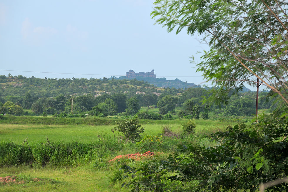
Near the interior roads approaching the fort, Garh Kundar appeared for the first time as a small dark interruption above the distant ridge line. Against the surrounding plains, the structure looked compact and isolated before the next terrain fold absorbed it back into the landscape.
The False Fort Entrance
The interior roads approaching Garh Kundar narrowed after the highway broke away toward the hill basin. Granite outcrops began replacing the flatter agricultural terrain seen earlier across Bundelkhand. Seasonal vegetation thickened around the road edges, absorbing long sightlines into the folds of the landscape.
The fort remained absent for most of the final approach. Tree cover, broken ridges, and shallow depressions interrupted visibility across the basin, forcing the road to reveal the hillscape in fragments rather than as a continuous horizon.
The auto-rickshaw stopped near a small cluster of temporary vendor stalls positioned below the staircase. Plastic sheets stretched over bamboo frames sheltered bottled water, packaged snacks, and tea kettles blackened by constant use through the monsoon season.
Beyond the stalls, the climb began without transition. Wide sandstone slabs rose directly against the hillside, bordered by patterned paving blocks and low retaining walls supporting the slope.
A watchtower silhouette and sections of outer stone walls appeared above the ridge line, hinting at the fort hidden deeper into the hill.

The ascent felt closer to a ridge walk than the monumental entrances seen at larger Indian forts. Open sky remained visible above the staircase while scrub vegetation spread across both flanks of the hill.
The staircase widened and narrowed with the slope before bending toward the first stone gateway rising above the ridge. Moisture stains darkened the retaining walls lining the upper sections of the climb after the monsoon rain.

The gateway revealed a tall defensive façade supported by two rounded bastions flanking the entrance wall. A massive wooden gate sat recessed inside a pointed multi-foil brick archway, while a smaller wicket door remained open within the larger doorway, controlling entry into the fort one person at a time.
The broad staircase compressed toward the dark opening beneath the archway. Bright hillside light cut sharply against the shadow-heavy interior of the gate structure, forcing the movement line toward the smaller opening inside the larger door.

Inside the outpost structure, the atmosphere shifted away from the exposed hillside climb. Large retaining blocks and elevated wall sections expanded around the passage, creating layered interior spaces hidden from the staircase outside.
The path no longer moved in a direct line. Blind turns redirected the climb through concealed internal bends while damp stone walls carried moss growth along the lower seams. The structure interrupted visibility at every stage, withholding any clear understanding of what stood beyond the next wall.

Beyond the outpost, the path reduced into a narrow cobbled corridor bordered by dense vegetation and low parapet edges overlooking the basin slope. The fort vanished again from view, replaced by stone, foliage, and the confined geometry of the ridge itself.
The climb toward Garh Kundar no longer behaved like a direct ascent toward a visible destination. Unlike many Indian hill forts where the structure gradually reveals itself through the approach, Garh Kundar kept interrupting the climb through bends, vegetation, and concealed passages that withheld the fort from view.
The Hidden Climb to Garh Kundar
Beyond the outpost passage, the route opened into the first uninterrupted view of Garh Kundar’s main fort façade. Dark stone bastions rose above the hillside while the upper residential levels emerged in stacked vertical layers beneath the watchtowers and chhatris.
The climb no longer behaved like the direct ascent seen at most Indian hill forts. The route curved through the hillside in controlled segments, revealing the fort in fragments while concealing the exact approach beneath the bastions.

A low stone parapet guided the path along the ridge edge before the surface shifted into a narrow switchback staircase climbing toward the main entrance. Small step heights slowed the ascent into a measured rhythm while the curved alignment prevented any direct run toward the upper gate.
The upper residential floors remained visible across most of the climb while the access route did not. Sections of the staircase disappeared behind thick vegetation, retaining walls, and projecting bastions before reappearing again higher along the slope.
Late monsoon cloud cover kept shifting across the exposed hillside. Grey light flattened the colour of the masonry before brief sunlight returned across wet stone, moss, and scrub vegetation growing between the retaining walls.
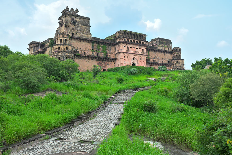
The ascent controlled movement long before the main gate came into view. Each curve restricted visibility across the next stretch of the climb while the elevated bastions retained clear views over the approach below.
Looking back from the upper edge of the pathway changed the scale of the landscape again. The earlier outpost appeared reduced to a small defensive block against the hillside while the plains spread outward beyond the basin ridges toward Niwari.

From the upper path, the earlier climb finally became legible as a layered defensive sequence rather than a single approach route. The outpost, curved staircase, ridge edges, and concealed turns aligned into one continuous system controlling visibility, movement, and access into the fort.
Beneath the Courtyard of Garh Kundar
The upper entrance passage ended without leading directly into the palace courtyard. Instead, the route dropped back into the masonry through a lower vaulted gallery hidden beneath the main residential levels.
Light disappeared again inside the stone corridor. Thick pillars divided the interior into narrow movement channels while damp air carried the smell of wet rock, moss, and enclosed masonry left behind by the monsoon season.

The interior geometry disrupted orientation in the same way as the outer climb. The vaulted hall concealed the direction of the courtyard while the structural pillars blocked long visibility across the chamber. Small shafts of daylight entered through narrow openings cut into the upper masonry.
Local Bundelkhand folklore connects these lower chambers with the most persistent story surrounding Garh Kundar. According to stories still repeated around the fort, a wedding party entered the underground levels decades ago during peak summer heat and never returned. Search teams later explored the chambers without finding any trace of the group.
The story survives because the lower structure still feels unfinished and unreadable. Multiple corridors branch beneath the courtyard through collapsed sections, blocked passages, and dark ventilation shafts that prevent any clear understanding of the original underground layout.

Beyond the vaulted section, the passage opened into a small intermediate landing exposed to daylight. Moss-covered defensive walls bordered the platform while a dark doorway continued upward beneath the palace structure.
The transition altered the scale of movement again. After the enclosed stone gallery below, the open landing created a short visual pause before the route narrowed back into the final staircase leading toward the courtyard surface.
The last staircase climbed through a deep masonry cut embedded directly into the upper level. Wet green moss spread across the retaining walls while the upper palace façades rose vertically above the trench-like opening.

The staircase did not emerge beside the courtyard. It emerged through it. The stone floor opened around the stairwell like a structural incision, exposing the exact connection between the subterranean movement layers and the upper residential level.
Direct sunlight washed across the courtyard surface while the lower entry passage remained in complete darkness beneath the opening. The contrast revealed how the fort separated hidden circulation routes from the exposed administrative and residential spaces above.
Stepping out from the stair cut transformed the spatial scale of Garh Kundar for the first time since the climb began. Narrow passages, blind turns, defensive curves, and enclosed galleries gave way to a vast open courtyard framed by layered arcades and upper residential façades.

The circular stone shaft positioned near the foreground anchored the relationship between the two worlds. Above ground, it appeared as part of the courtyard geometry. Below ground, the same opening functioned as a light well feeding daylight into the vaulted chambers beneath the palace floor.
From the courtyard level, the earlier climb finally began to make sense as a single connected route through the fort. Staircases crossed the hillside below, gateways interrupted the ascent, and lower galleries redirected movement beneath the palace levels before everything disappeared beneath the open courtyard surface.
The Upper Galleries of Garh Kundar
Beyond the central courtyard, movement through Garh Kundar continued along the inner residential edges rather than through open palace chambers. Arched halls, elevated corridors, and exposed staircases linked the upper floors into a layered circulation network overlooking the courtyard below.
The architecture shifted again from the defensive compression of the lower passages. These intermediate levels balanced concealment with observation, allowing movement across the fort while maintaining controlled visibility through narrow openings, screened galleries, and elevated walls.

One long interior hall extended parallel to the courtyard, directing movement through the residential block while keeping the upper levels visually segmented. Side openings punctured the thick structure at intervals, allowing narrow bands of daylight to cut across the floor while keeping the passage concealed from the exterior.
The hall functioned less like a ceremonial palace space and more like an internal route linking the upper residential sections. Movement remained controlled through segmented visibility rather than open access across the upper floors.

At the far edge of the courtyard, a straight open staircase climbed toward the higher terraces above the residential floors. Tall parapet walls boxed the ascent into a narrow upward axis, limiting outward visibility until the staircase reached the upper landing.
Unlike the concealed exterior climb below, this staircase prioritised vertical control over concealment. The ascent remained direct and exposed while the enclosing parapet walls restricted long lateral sightlines across the upper levels.
The Scale of Garh Kundar
Beyond the upper stair levels, Garh Kundar opened into the first uninterrupted sense of the fort’s true scale. Earlier sections of the approach that felt isolated across the hillside now aligned into one continuous structure extending through the ridge above the basin.
The climb no longer felt like separate gates, staircases, and passages encountered in fragments below. From within the upper complex, the fort finally revealed the full extent of its spread across the landscape.

Human movement across the upper approach roads altered the scale of the fort once again. Stone surfaces that appeared measured during the ascent reduced sharply against the height and spread of the surrounding structures.
From the ridge edge, the earlier climb no longer appeared fragmented. The outpost below, concealed stairways, interior passages, and courtyard levels aligned into a single route unfolding through the landscape of Garh Kundar.
Reconstructing Garh Kundar
From the upper terraces, the earlier climb across Garh Kundar finally aligned into a single continuous route. Staircases hidden behind bastions, gateways concealed inside the hillside, and ridge paths that disappeared below the vegetation now connected into one layered ascent across the landscape.

The sequence revealed how Garh Kundar relied less on monumental visibility and more on interruption. Terrain and fortification worked together to keep the fort fragmented until the final upper levels.
Leaving Garh Kundar
Garh Kundar receded after the return journey began. Beyond the outer ridges, the fort disappeared behind vegetation, rock, and folds in the monsoon landscape.
A brief spell of rain crossed the interior roads on the return toward Swargashram Jharna, leaving shallow puddles across the route. After the enclosed passages and concealed turns inside the fort, the landscape felt altered in its openness.
Water moved through wet stone, vegetation, and monsoon runoff without the interruptions that shaped the fort above the ridges.

By the time the highway returned toward Jhansi, the memory of the climb had already begun to dissolve into the wider Bundelkhand landscape.
What remained was not a single image of the fort, but the experience of moving through a landscape where visibility never stayed constant for long.


